


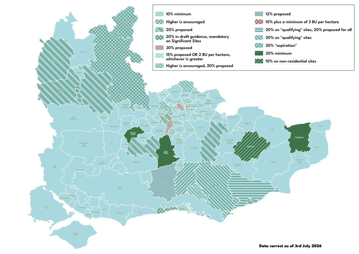
What Net Gain Do I Need?
Although the national minimum is 10%, some Local Planning Authorities (LPAs) have set their own higher thresholds. Have a look at the map below to see what your current (and upcoming) LPA minimum gain is:

What To Expect After Your Project Is Approved

When you receive approval, there will be a condition asking for a document known as a Habitat Management and Monitoring Plan (HMMP) to be submitted, along with a final version of your BGP. The HMMP provides detailed information on the proposed habitat protection, enhancement, and creation measures. It also outlines the habitat management and a monitoring schedule covering the full 30-year period (starting AFTER the development is complete).

As with most planning submissions, you will also likely have additional ecology-related conditions to discharge. These might include a Landscape and Ecology Management Plan (LEMP), Construction Environmental Management Plan (CEMP), Ecological Mitigation/Management Plan (EMP), lighting strategy for bats, or further reports following any pre-commencement surveys. These can be discharged at the same time as the HMMP and final BGP.

In addition, if you are using an off-site parcel of land for your mitigation measures, the parcel of land will need to be entered onto the national biodiversity gain sites register, and a Section 106 or othe rconservation covenant will need to be set up. If applicable, a proof of biodiversity unit or Statutory Credit purchase will need to be submitted to the LPA once the draft BGP is approved, with the documents all provided prior to works starting.

Following the completion of works, you will need to manage the habitats for a period of 30 years. Your ecologist will visit regularly to make sure all is well, and will advise you if they believe any actions are needed to maintain the habitat in the agreed condition.
Wealden 10% BNG (20% BNG on “qualifying” sites); Rother 10% BNG (20% BNG on “qualifying” sites); Hastings 10% BNG (20% BNG proposed); Eastbourne 10% BNG (higher is encouraged, 20% BNG proposed); Lewes 10% BNG (higher is encouraged); Brighton & Hove 10% BNG; South Downs 10% BNG; Thanet 10% BNG; Dover 10% BNG; Canterbury 20% BNG; Folkestone & Hythe 10% BNG; Tunbridge Wells 10% BNG; Ashford 10% BNG; Maidstone 10% BNG (20% BNG on residential sites); Swale 10% BNG; Tonbridge and Malling 10% BNG; Medway 10% BNG; Gravesham 10% BNG; Dartford 10% BNG; Sevenoaks 10% BNG (20% BNG proposed); Ebbsfleet Development Corporation 10% BNG; Adur 10% BNG (20% BNG encouraged, mandatory on Significant Sites); Worthing 10% BNG (20% BNG encouraged, mandatory on Significant Sites); Arun 10% BNG; Chichester 10% BNG; Horsham 10% BNG (12% BNG proposed); Mid Sussex 10% BNG (higher is encouraged); Crawley 10% BNG; Tandridge 10% BNG; Reigate and Banstead 10% BNG; Epsom and Ewell 10% BNG; Mole Valley 20% BNG; Elmbridge 10% BNG; Spelthorne 10% BNG; Runnymede 10% BNG; Surrey Heath 10% BNG; Woking 10% BNG; Guildford 20% BNG; Waverley 10% BNG; West Berkshire 10% BNG; Reading 10% BNG; Wokingham 10% BNG; Windsor and Maidenhead 10% BNG; Slough 10% BNG; Bracknell Forest 10% BNG; Basingstoke and Deane 10% BNG; Hart 10% BNG; Rushmoor 10% BNG; East Hampshire 10% BNG; Winchester 10% BNG; Test Valley 10% BNG; Eastleigh 10% BNG; Southampton 10% BNG; Fareham 10% BNG; Gosport 10% BNG; Portsmouth 10% BNG; Havant 10% BNG; New Forest 10% BNG; Isle of Wight 10% BNG; Enfield 10% BNG; Waltham Forest 10% BNG; Redbridge 10% BNG; Havering 10% BNG; Barking and Dagenham 10% BNG; London Legacy Development Corporation 10% BNG; Bexley 10% BNG; Greenwich 10% BNG; Newham 10% BNG; Tower Hamlets 10% BNG; Lewisham 10% BNG; Bromley 10% BNG; Croydon 10% BNG; Sutton 10% BNG; Merton 10% BNG; Wandsworth 10% BNG; Lambeth 10% BNG; Southwark 10% BNG; Kensington and Chelsea 10% BNG; Westminster 10% BNG; Hammersmith and Fulham 10% BNG; Hounslow 10% BNG; Richmond upon Thames 10% BNG (20% BNG proposed); Kingston upon Thames 10% BNG (30% BNG proposed); Hillingdon 10% BNG; Old Oak and Park Royal Development Corporation 10% BNG; Ealing 10% BNG; Brent 10% BNG; Harrow 10% BNG (15% BNG proposed); Camden 10% BNG; Barnet 10% BNG; Haringey 10% BNG; Islington 10% BNG; Hackney 10% BNG; City of London 10% BNG; Cherwell 10% BNG; West Oxfordshire 10% BNG; Oxford 10% BNG; Vale of White Horse 10% BNG (20% BNG proposed); South Oxfordshire 10% BNG (20% BNG proposed); Buckinghamshire 10% BNG (20% BNG “aspiration”); Milton Keynes 10% BNG (20% BNG “aspiration”)


